Search
 
Write
 
Forums
 
Login
"Let there arise out of you a band of people inviting to all that is good enjoining what is right and forbidding what is wrong; they are the ones to attain felicity".
(surah Al-Imran,ayat-104)
Image Not found for user
User Name: Aqil_Sajjad
Full Name: Aqil Sajjad
User since: 25/Oct/2008
No Of voices: 9
Cartels by Dr Farrukh Saleem
Views:4734 Replies:0
Zardari's strange statement
Views:2742 Replies:0
Secret details of Swat peace accord by Hamid Mir
Views:3218 Replies:0
Method of appointing judges
Views:3592 Replies:0
Musharraf-Benazir plan was to keep Sharifs away: ex-UK envoy
Views:2846 Replies:0
Pictures prove US drones parked in Pakistan
Views:9934 Replies:5
Impatience with democracy
Views:2703 Replies:1
Appointment of judges
Views:2806 Replies:0
Shameful curbs on coverage of the CJ issue
Views:2629 Replies:0

Click here to read All Articles by User: Aqil_Sajjad

 
 Views: 9934   
 Replies: 5   
 Share with Friend  
 Post Comment  
Pictures prove US drones parked in Pakistan
Wednesday, February 18, 2009
By Omar R Quraishi

Shamsi airbase in Pakistan in 2006

Recent image of the Shamsi airbase in Pakistan's southwestern provinc of Baluchistan
 
KARACHI: Amid the raging controversy over US drones and whether they take off from Afghanistan or Pakistan, at least one fact has been definitely confirmed: the drones have been parked on Pakistani soil.
 
Two pictures of an unidentified flying strip in Balochistan "” bearing the coordinates 27 degrees 51 minutes North, 65 degrees and 10 minutes East "” prove
that Pakistani ground was being used, at least until 2006.
 
Both the pictures are still available on Google Earth, which maps every corner of the world through a satellite and internet users can zoom in to see every
detail, even cars parked in front of their drive ways. The pictures on Google Earth are not live but the satellite updates them after every few months.
 
The first picture of the drones on the Pakistani soil, taken in 2006, has three drones, all Global Hawks. The picture has coordinates and they can be vaguely
read as 27 degrees, 51 minutes North; 65 degrees, 10 minutes East. These coordinates place the strip not far from the nearby Jacobabad airbase which is
around 28 degrees north, 68 degrees east.
 
The strip, which is around 2,800 metres long, is close to the town of Wadh in Kharan district which straddles the Sindh-Balochistan border. Also, the grab shows the infrastructure surrounding the airstrip and the V-shaped structure towards the bottom left of the picture is in fact a hanger.
 
The image shows three Global Hawks on the ground and these are similar to the ones operated by the US defence department. These are high-altitude reconnaissance aircraft and their endurance is such that one is known to have flown from Edwards Air Force Base in Los Angeles County to an airbase in Australia "” the
flight lasting 22 hours. Also, a Global Hawk set the world endurance record for unmanned flight on March 1, 2001, when it flew for over 30 hours "” also
flying out from Edwards Air Force Base.
 
A closer analysis of the more recent Google Earth picture (labelled "˜2009') with more or less the same coordinates as the "˜2006' picture (differing only
by a few minutes) suggests that several new structures have been built since 2006.
 
The hanger has been completely built and has an interesting configuration, much like a clam. An expert who saw this picture suggested that "what appeared
to be anti-missile" cannons could be seen deployed around the hangar area and the parking bay section away from the main strip. On the other (western)
side of the airstrip (though not seen in the "˜2009' picture) are also what seems to be living barracks built within what appears to be a perimeter wall
or enclosure.
 
However, a comparison of the "˜2006' and "˜2009' pictures clearly shows that the airstrip in question is the same "” especially given that the latitude and
longitude coordinates are almost identical "” differing by a few minutes in both cases.
 
While both the Pakistani defence and foreign ministers have denied that the Pakistani bases are being used to launch drones, it is a matter of record that
the Pakistani bases were "” and perhaps still are "” being used by the Americans and for which payment is made to the government of Pakistan.
 
In fact, in April 2003, the Centcom website had by mistake released classified details of all the assistance and help Pakistan had provided to the US during
its invasion of Afghanistan to wipe out the Taliban. The website not only confirmed that bases were being used but had stated that 57,000 bombing sorties
had taken off from the Pakistani soil to attack the Taliban. The data released by the Centcom had also stated that Pakistan had suffered a loss of $10
billion because of US invasion of Afghanistan.
 
Shortly after this data was picked up by the international media, the Centcom website was cleansed and all references to the statistics were removed from
the website. The airport where the three US drones are parked is about 120km southwest of Kharan, which is being used by the American forces. A drone had
also crashed in the same area and its wreckage was found in the mountains. It was shifted to Shamsi airport.
 Reply:   Ahmed Mukhtar, Pakistan's biggest idiot, tough competition Qureshi & Rehman
Replied by(Noman) Replied on (21/Feb/2009)
He is saying Pakistan soil only used for landing, then he should tell after landing Trucks carry them to Afghanistan for next flight?
.
 
 Reply:   Government accord exist for Drone Plane and air basis. American News Paper
Replied by(Noman) Replied on (20/Feb/2009)
.

 
 Reply:   Google Earth reveals secret history of US base in Pakistan
Replied by(Noman) Replied on (19/Feb/2009)
.
From
February 19, 2009

Google Earth reveals secret history of US base in Pakistan

Shamsi airbase in Pakistan in 2006

Recent image of the Shamsi airbase in Pakistan's southwestern provinc of Baluchistan
Latest Image


Exclusive: secret CIA drone base | Graphic: 2006 image | Graphic: recent image
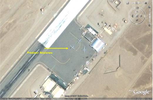
The US was secretly flying unmanned drones from the Shamsi airbase in Pakistan's southwestern province of Baluchistan as early as 2006, according to an image of the base from Google Earth.
The image "” that is no longer on the site but which was obtained by The News, Pakistan's English language daily newspaper "” shows what appear to be three Predator drones outside a hangar at the end of the runway. The Times also obtained a copy of the image, whose co-ordinates confirm that it is the Shamsi airfield, also known as Bandari, about 200 miles southwest of the Pakistani city of Quetta.
An investigation by The Times yesterday revealed that the CIA was secretly using Shamsi to launch the Predator drones that observe and attack al-Qaeda and Taleban militants around Pakistan's border with Afghanistan.
 
US special forces used the airbase during the invasion of Afghanistan in 2001, but the Pakistani Government said in 2006 that the Americans had left. Both sides have since denied repeatedly that Washington has used, or is using, Pakistani bases to launch drones. Pakistan has also demanded that the US cease drone attacks on its tribal area, which have increased over the last year, allegedly killing several "high-value" targets as well as many civilians.
The Google Earth image now suggests that the US began launching Predators from Shamsi "” built by Arab sheiks for falconry trips "” at least three years ago.
The advantage of Shamsi is that it provides a discreet launchpad within minutes of Quetta "” a known Taleban staging post "” as well as Taleban infiltration routes into Afghanistan and potential militant targets farther afield.
Google Earth's current image of Shamsi "” about 100 miles south of the Afghan border and 100 miles east of the Iranian one "” undoubtedly shows the same airstrip as the image from 2006.
There are no visible drones, but it does show that several new buildings and other structures have been erected since 2006, including what appears to be a hangar large enough to fit three drones. Perimeter defences "” apparently made from the same blast-proof barriers used at US and Nato bases in Afghanistan "” have also been set up around the hangar.
A compound on the other side of the runway appears to have sufficient housing for several dozen people, as well as neatly tended lawns. Three military aviation experts shown the image said that the aircraft appeared to be MQ1 Predator unmanned aerial vehicles "” the model used by the CIA to observe and strike militants on the Afghan border.
The MQ1 Predator carries two laser-guided Hellfire missiles, and can fly for up to 454 miles, at speed of up to 135mph, and at altitudes of up to 25,000ft, according to the US Air Force website www.af.mil
The News reported that the drones were Global Hawks "” which are generally used only for reconnaissance, flying for up to 36 hours, at more than 400mph and an altitude of up to 60,000ft. Damian Kemp, an aviation editor with Jane's Defence Weekly, said that the three drones in the image appeared to have wingspans of 48-50ft.
"The wingspan of an MQ1 Predator A model is 55ft. On this basis it is possible that these are Predator-As," he said. "They are certainly not RQ-4A Global Hawks (which have a wingspan of 116ft 2in)."
Pakistan's only drones are Italian Galileo Falcos, which were delivered in 2007, according to a report in last month's Jane's World Air Forces.
A military spokesman at the US Embassy in Islamabad declined to comment on the images "” or the revelations in The Times yesterday.
Major-General Athar Abbas, Pakistan's chief military spokesman, was not immediately available for comment. He admitted on Tuesday that US forces were using Shamsi, but only for logistics.
He also said that the Americans were using another air base in the city of Jacobabad for logistics and military operations. Pakistan gave the US permission to use Shamsi, Jacobabad and two other bases "” Pasni and Dalbadin "” for the invasion of Afghanistan in October 2001.
The image of the US drones at Shamsi highlights the extraordinary power "” and potential security risks "” of Google Earth.
Several governments have asked it to remove or blur images of sensitive locations such as military bases, nuclear reactors and government buildings. Some have also accused the company of helping terrorists, as in 2007, when its images of British military bases were found in the homes of Iraqi insurgents.
Last year India said that the militants who attacked Mumbai in November had used Google Earth to familiarise themselves with their targets. Google Street View, which offers ground-level, 360-degree views, also ran into controversy last year when the Pentagon asked it to remove some online images of military bases in America.


 Reply:   And Still they have courage to deny
Replied by(Noman) Replied on (19/Feb/2009)
.
Our beloved and most honored Defense minister straightaway denied the claim...


 Reply:   Here is one of the picture !
Replied by(Wajeeh) Replied on (19/Feb/2009)
one of the picture taken by Google ...

The picture of the drones on the Pakistani soil, taken in 2006, has three drones, all Global Hawks. The picture has coordinates and they can be vaguely read as 27 degrees, 51 minutes North; 65 degrees, 10 minutes East. These coordinates place the strip not far from the nearby Jacobabad airbase which is around 28 degrees north, 68 degrees east.

One can easily verify the authenticity of the picture taken in 2006 with the 2009 image found online on Google maps by merely inserting the above coordinates in satellite mode.


Please send your suggestion/submission to webmaster@makePakistanBetter.com
Long Live Islam and Pakistan
Site is best viewed at 1280*800 resolution